IEEE/RSJ International Conference on Intelligent Robots and Systems (IROS) 2026 Aerial-ground robotics

Seeing Where to Deploy

Metric RGB-Based Traversability Analysis for Aerial-to-Ground Hidden Space Inspection

Seoyoung Lee1, Shaekh Mohammad Shithil2, Durgakant Pushp2, Lantao Liu2, Zhangyang “Atlas” Wang1

1The University of Texas at Austin 2Indiana University Bloomington

The problem

A safe landing region must be seen before it can be reached.

Hidden spaces such as culverts and ventilation systems are difficult to access from the ground. A UAV can scout from above and carry a compact UGV, but deployment requires reliable metric terrain reasoning from a constrained aerial view.

Abstract

Inspection of confined infrastructure such as culverts often requires accessing hidden spaces whose entrances are reachable primarily from elevated viewpoints. Aerial–ground cooperation enables a UAV to deploy a compact UGV for interior exploration, but selecting a suitable deployment region from aerial observations requires metric terrain reasoning involving scale ambiguity, reconstruction uncertainty, and terrain semantics.

We present a metric RGB-based geometric–semantic reconstruction and traversability analysis framework for aerial-to-ground hidden space inspection. A feed-forward multi-view RGB reconstruction backbone produces dense geometry, while temporally consistent semantic segmentation yields a 3D semantic map. To enable deployment-relevant measurements without requiring LiDAR-based dense mapping, we introduce an embodied motion prior that recovers metric scale by aligning predicted camera motion with onboard platform egomotion. From the metrically grounded reconstruction, we construct a confidence-aware geometric–semantic traversability map and evaluate candidate deployment zones under explicit reachability constraints. Experiments on a tethered UAV–UGV platform demonstrate reliable deployment-zone identification in hidden space scenarios.
01

Geometry meets semantics

Feed-forward multi-view reconstruction and temporally consistent segmentation produce a coherent semantic 3D scene from RGB video.

02

Scale becomes metric

Onboard egomotion grounds relative visual predictions in real-world scale without using dense LiDAR terrain maps.

03

Terrain becomes actionable

Geometry, semantics, and reconstruction confidence combine into a bird's-eye-view map for deployment-zone selection.

Integrated system

Aerial access, ground-level inspection.

The DJI Matrice M600 carries a compact tracked ground robot and observes potential deployment regions from above. The platform includes a RealSense camera, Jetson Xavier NX, and a Livox Mid-360 used for FAST-LIO egomotion. Dense reconstruction and traversability use RGB observations, not LiDAR point clouds.

  1. SurveyCapture a short top-down RGB sequence over the hidden-space entrance.
  2. ReconstructPredict dense geometry and temporally stable semantic regions.
  3. GroundAlign predicted camera motion with platform egomotion to recover metric scale.
  4. EvaluateScore terrain and retain safe, reachable candidate deployment zones.
DJI Matrice M600 aerial platform with its sensor payload beside the compact tracked UGV
Integrated aerial-ground robotic system. The compact UGV supports interior inspection after aerial transport and deployment.

Proposed framework

From overhead video to deployment-aware terrain.

The pipeline separates perception, physical scale recovery, and deployment reasoning while keeping every stage tied to the final decision.

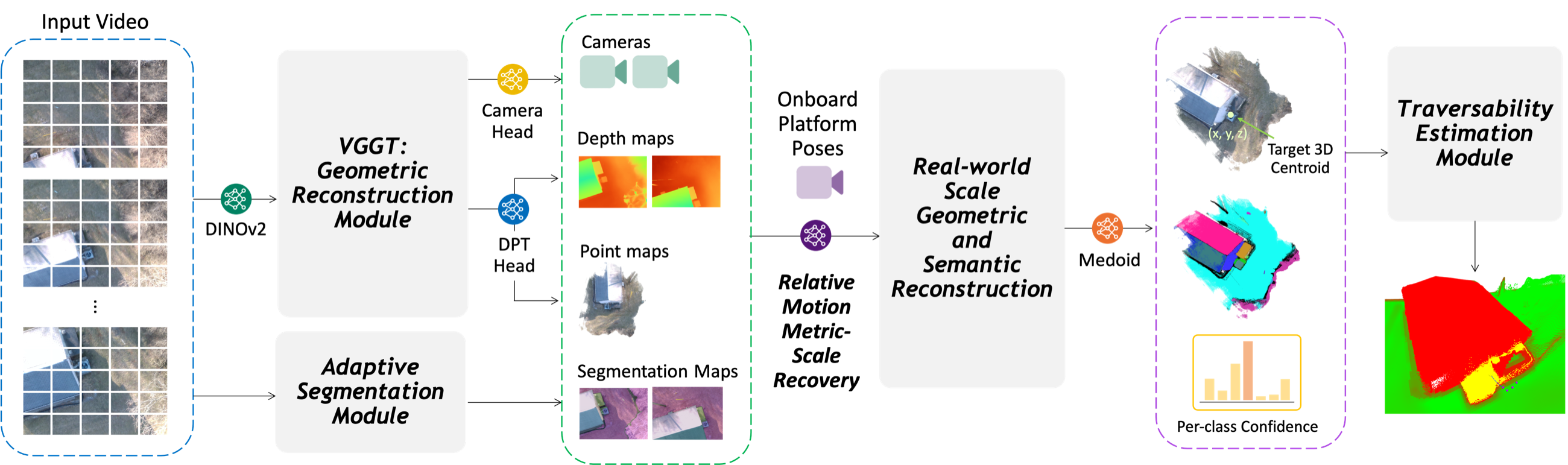
Pipeline diagram showing top-down RGB input, VGGT geometry and adaptive segmentation, embodied metric grounding, target extraction, and traversability estimation
Overview of the proposed pipeline. Top-down RGB frames drive geometric reconstruction and adaptive segmentation; egomotion grounds the result in metric scale before traversability analysis. Open the full-resolution figure.

Geometric reconstruction

Dense, feed-forward 3D

VGGT predicts camera parameters, depth, and confidence for a set of uncalibrated RGB frames. Depth unprojection produces the scene geometry without scene-specific optimization.

Adaptive segmentation

Consistent labels over time

New object masks are discovered at keyframes and propagated across the video, then lifted into 3D to align semantic identity with reconstructed geometry.

Deployment reasoning

Scores with physical meaning

A confidence-aware bird's-eye-view grid combines local slope, roughness, clearance, and semantic compatibility into a continuous traversability score.

Technical overview

The system in one minute.

A concise walkthrough of data collection, metric reconstruction, traversability analysis, and deployment planning.

One-minute video submitted with the IROS 2026 paper.

Embodied metric grounding

Relative visual geometry, grounded in real motion.

Monocular reconstruction has no absolute scale. The method aligns relative camera displacements predicted from RGB with metric displacements from onboard state estimation, then applies the recovered similarity transform to every camera and 3D point.

Why it matters: slope, obstacle clearance, and support-footprint variation only become deployment constraints when reconstruction is expressed in physical units.

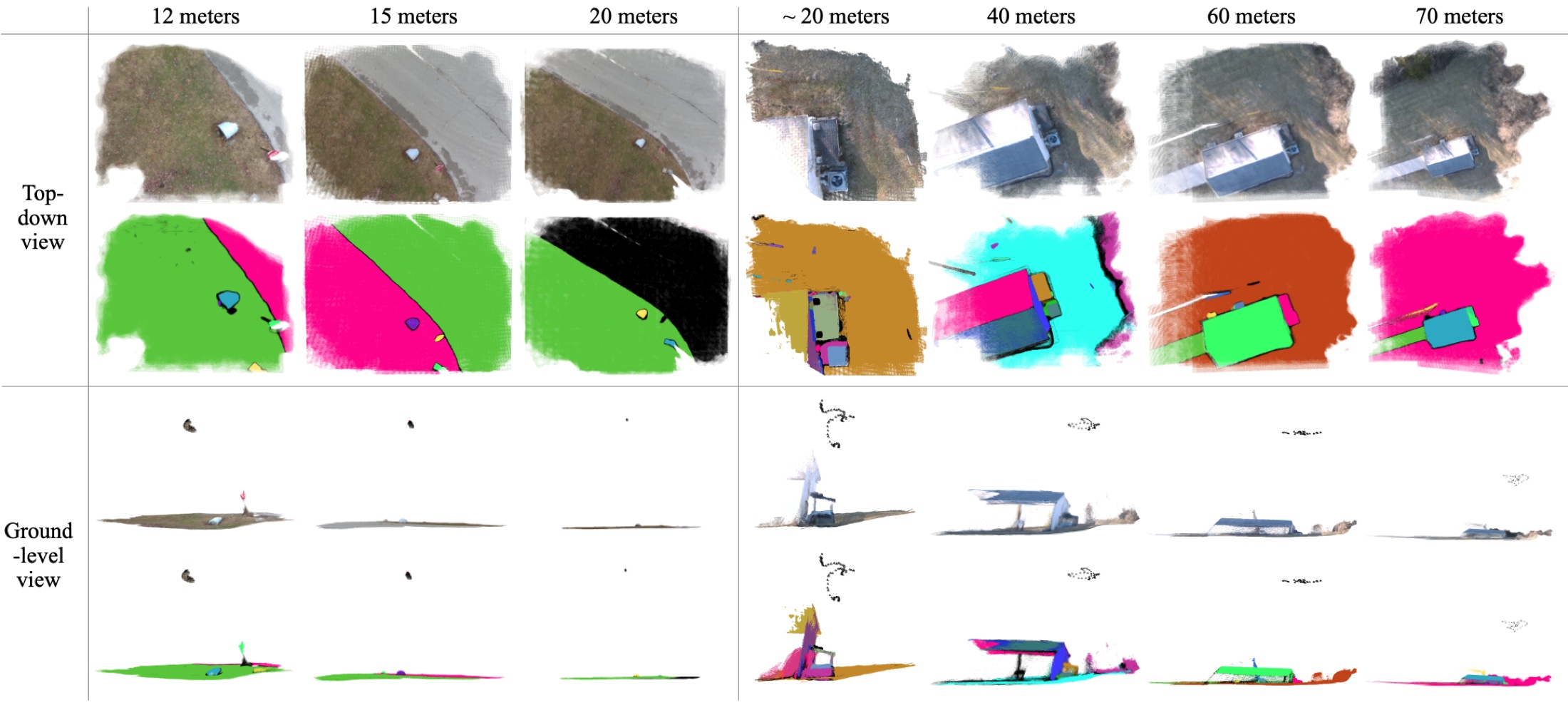
Top-down and ground-level geometric and semantic reconstructions of culvert and vent scenes from UAV elevations between 12 and 70 meters
RGB-based geometric and semantic reconstruction across flight elevations. The method preserves meaningful scene structure from purely top-down observations in culvert and vent scenarios.

Pose estimation

Relative motion improves all reported trajectory metrics.

Results are averaged over the field-collected inspection data. Lower values are better.

Pose estimation comparison with and without relative motion grounding
Variant ATE ↓ RPEtrans RPErot
Ours 0.222 0.338 1.920
Ours + relative motion 0.194 0.310 1.878

Traversability and deployment

Geometry finds flat ground. Semantics catches what shape alone misses.

A planar rocky region can look safe after geometric smoothing. Semantic fusion suppresses such terrain even when its local slope and roughness appear acceptable.

Side-by-side RGB reconstruction, semantic segmentation, geometric traversability, and geometry-semantic fusion maps
From left: RGB-based reconstruction, semantic segmentation, geometric traversability, and geometric-semantic fusion. Green indicates higher traversability and red indicates lower traversability.

Field results

Fusion is more conservative and more accurate.

Ground-truth bird's-eye-view cells are labeled using terrain semantics and deployment safety criteria. Scores are thresholded at 0.5 for binary comparison.

0.958 mean accuracy for geometric-semantic fusion
Traversability accuracy
Model mACC ↑ aAcc ↑ ROC AUC ↑ MSE ↓
Geometric 0.779 0.841 0.926 0.113
Fusion 0.958 0.938 0.948 0.042
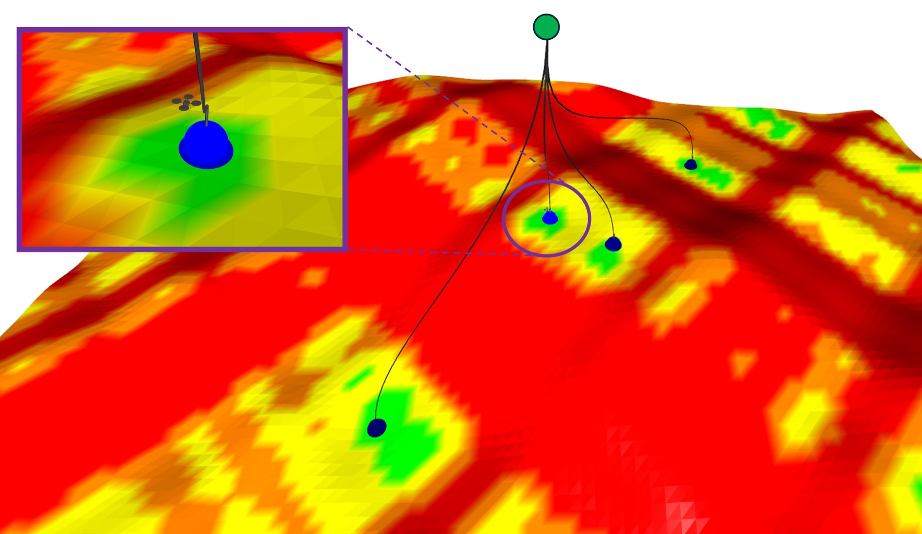
Candidate aerial deployment locations and trajectories over a color-coded traversability surface
Candidate deployment locations and feasible UAV trajectories on the traversability surface.

Planning connection

From terrain scores to reachable targets.

Candidate zones are selected from high-traversability cells near the target region. A hazard-aware planner generates dynamically feasible trajectories from the UAV state to selected deployment locations while avoiding terrain marked unsafe.

Physical UGV release, post-deployment traversal, retrieval, and safety-aware failure handling remain future end-to-end validation steps.

Authors

Citation

Cite our work.

The paper is available as arXiv:2603.14639, and the one-minute technical overview is available above. Code will be linked when it is publicly available.

Seoyoung Lee, Shaekh Mohammad Shithil, Durgakant Pushp, Lantao Liu, and Zhangyang Wang. “Seeing Where to Deploy: Metric RGB-Based Traversability Analysis for Aerial-to-Ground Hidden Space Inspection.” 2026 IEEE/RSJ International Conference on Intelligent Robots and Systems (IROS), 2026.

@inproceedings{lee2026seeingwheretodeploy,
  title     = {Seeing Where to Deploy: Metric RGB-Based Traversability Analysis for Aerial-to-Ground Hidden Space Inspection},
  author    = {Lee, Seoyoung and Shithil, Shaekh Mohammad and Pushp, Durgakant and Liu, Lantao and Wang, Zhangyang},
  booktitle = {2026 IEEE/RSJ International Conference on Intelligent Robots and Systems (IROS)},
  year      = {2026},
  url       = {https://arxiv.org/abs/2603.14639}
}